Environment Canada issues snowfall warning for the GTA Saturday
Posted January 16, 2020 4:37 pm.
Last Updated January 17, 2020 11:05 pm.
**NOTE: these are early predictions and forecast models can change several times a day. Meteorologists will have updates every 10 minutes on 680 NEWS.
—-
It’s been a really quiet January weather-wise and we haven’t seen any notable snowfall since around early December.
That all changes this weekend with a big serving of snow on the way for Saturday.
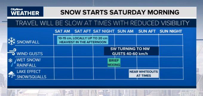
Environment Canada issued a snowfall warning Friday saying “snow will be heavy at times Saturday morning and afternoon.”
Early predictions of snow totals show about 10 to 15 centimetres. In comparison, we’ve had a total of just 10 centimetres of snow all this month.
Meteorologist Natasha Ramsahai has a breakdown of how it’s expected to play out:
What’s expected in terms of snow on Sat. Jan. 18, 2020. NATASHA RAMSAHAI/CITYNEWS
What:
This is a very challenging snow forecast due to the period of warming expected Saturday night. The models have been trending too warm over these last couple of days. That means we may actually stay colder for longer = more snow (hence the snowfall warning). North and east GTA still expected to not get any rain mixing in at all and stay as straight snow.
When:
- Overnight tonight – 9 a.m.: chance for light lake effect flurries before the main system snow
- 9 a.m. – 10 a.m.: main system snow starts as light and fluffy
- 11 a.m. – 6 p.m.: heaviest snowfall with rates of 1-2 cm/hr expected; changeover to wet snow with high water content (hard to shovel)
- 6 p.m. – 10 p.m.: chance for rain mixing in downtown westward to Hamilton and around the Golden Horseshoe
- 10 p.m.: starting to taper, still some light snow to the north and east
- Flurries overnight
- Sunday: on/off flurries. Cold front could bring brief, heavy snow midday (very short-lived)
Who and how much:
- For areas that don’t mix in rain, amounts could be in the 15-20 cm range (this is the north and east GTA including York-Durham).
- Most of Toronto, 12-15 cm. A mm or two of rain downtown westward.
- Hamilton to Niagara, less snow (7-12 cm), more rain (2-5 mm)
Impacts:
- High snowfall rates of 1-2 cm/hr in the middle of the day will make it hard for snow plows to keep up…fast accumulation
- Snow type will be light and fluffy and blowy to start (visibility issues), switching to heavy, wet snow late afternoon (hard to shovel)
- For areas that get rain after 10-15 cm of snow could see localized flooding as storm drains will be blocked with snow
- Cold front coming through Sunday midday could give brief, sudden whiteout conditions as it passes…potential for vehicular accidents due to near zero visibility
- Behind this, plummeting temperatures will make things very icy Sunday night
- Dangerous wind chills near -20 by Monday morning means moderate risk of frostbite returns
What NOT to call this:
- A weather bomb
- A blizzard
- Polar vortex
- Weird and/or wacky
- Unusual
- Unexpected
Stay tuned to 680 NEWS’ weather page for the latest updates as we brace for the coming inclement weather.